
A Chronological History of the Hopewell Baptist Church and
Its Original Property
and
A Chronological History of the Expansion of the
Hopewell Baptist Church Cemetery
By Richard L. Porter
Completed for The Hopewell Museum
Copyright © 2024 by Richard L. Porter and The Hopewell Museum. All rights reserved.
Chronological History of the Hopewell Baptist Church and
Its Original Property
1747
On June 19, 1747 a meeting was held that involved Isaac Eaton, an “Ordained Elder” of the Baptist Church, and members of the then informally organized Baptist congregation of Hopewell Township where it was agreed to build a meeting house, with four members chosen to serve as the “Managers to Build the Meeting house” (Registrum Baptismale 1749).
1747–1748
The construction of the meeting house, which was sited “on the Lot of Ground Given by Mr John Hart for Sd purpose” (see Parcel 1 on Figure 1), commenced with the “work to Draw the Stones Sometime in August 1747, and Sometime that winter following Got it fit to Keep meeting in” (Registrum Baptismale 1749).

Figure 1. Aerial photograph with an overlay showing the approximate bounds of the various parcels that were eventually combined to create the present Hopewell Baptist Church and Cemetery property (mapping completed by CPT Carrick O’Connor Porter).
Secondary sources (see Dean 1875; “Hopewell as it was About the Year 1800” 1881; Purington 1882; Ashton 1960) describe the original meeting house as a square single-story stone structure that stood on the site of the present Hopewell Baptist Church. It seems likely that the use of those portions of this original “Lot of Ground” adjacent to the new meeting house as a burying ground commenced at the same time. This new religious institution would come to be of such local importance that the village that developed around it was referred to as Hopewell Meeting House during the remainder of the eighteenth century. It would subsequently be known as the Hopewell Baptist Church (the name utilized in this document) and, after the major schism that led to the creation of “Old School” and “New School” Baptist church organizations during the second quarter of the nineteenth century, as the Hopewell Old School Baptist Church (Hunter and Porter 1992; Davis 2016; the latter name is the most commonly used today).
The ownership of the larger property from which this “Lot of Ground” was subdivided in 1747 is somewhat unclear. Although this larger property was later owned by John Hart, it may not have been in 1747. In his will, drawn up in 1779, Hart noted that the larger property was “lately purchased of Benjamin Stout Jr.” (New Jersey Will 1097J), with “lately” suggesting a more recent acquisition rather than one predating 1747. If, in fact, Hart did not own the larger property in 1747, it is likely that he acquired the “Lot of Ground” from the actual owner specifically for the purpose of granting it to the Baptist congregation.
John Hart was a prominent local citizen, judge, and farmer who served in the New Jersey Assembly, the New Jersey Provincial Congress, and the Continental Congress and is best known as a Signer of the Declaration of Independence in1776. Hart’s house and farmstead was sited a short distance to the north of the new meeting house, with some sections of his dwelling surviving as components of the Hart/Phillips House on Hart Avenue in Hopewell (Porter 2023; www.ushistory.org/declaration/signers/hart.html).
The above cited Registrum Baptismale or a Church Book was started by Isaac Eaton in 1749 to record baptisms and other important church-related matters and was utilized for that purpose until 1855 (Figure 2). As recorded in this “Church Book,” Eaton was formally ordained as the first Minister of the Hopewell Baptist Church on November 23, 1748. He is perhaps most renowned as the founder of the first Baptist Latin Grammar School in the United States, a college preparatory institution, with the said school established in Hopewell and including among its graduates a number of prominent ministers, most notably James Manning, the founder and first President of Rhode Island College, now Brown University. As stated on his tombstone Eaton “for upwards of 26 Years was PASTOR of this Church from the Care of which He was removed By Death On the 4th of July 1772”(www.findagrave.com) (Ashton 1960).

Figure 2. Title Page of the Registrum Baptismale or a Church Book of the Hopewell Baptist Church. This manuscript is now preserved as part of the collections of the Hopewell Museum.
1753
Work continued on the building for several years, as indicated by the appointment of a Manager “to finish the Meeting house” on September 16, 1753 (Registrum Baptismale 1749).
1756
On August 21, 1756 it was reported that there remained “Some Small Part to finish Yet” on the meeting house (Registrum Baptismale 1749).
1768
On February 20, 1768 it was recorded that it had been “Proposed to Obtain a Deed for the Meeting House Lot from John Hart Esquire” (Registrum Baptismale 1749).
1769
On June 17, 1769 it was recorded that “Mr John Hart Signed the Deed for the Meeting House and Lott of Land containing three Quarters of an Acre” (Registrum Baptismale 1749). A copy of this deed has not been identified, either locally or within the records of the Colony of New Jersey or Hunterdon County.
An analysis of later land records for the current church property (see “Chronological History of the Expansion of the Hopewell Baptist Church Cemetery” below) and for properties adjacent to the east and west (see below under 1789 and 1797) define this original three-quarter acre lot as having had frontage along the present West Broad Street of 165 feet and as being 198 feet in depth. A property with these dimensions encompasses exactly three-quarters of an acre of land (see Parcel 1 on Figure 1).
On December 5, 1769 “A Charter for the Baptist Congregation in Hopewell” was formally granted by the colonial government, and among the congregation’s responsibilities under the charter was the requirement that Trustees be selected to participate in the governance of the church and that the activities of the Trustees be recorded. This led to the creation of “A Book of Records For the Trustees of the Baptist Church in Hopewel New Jersey,” which was started in1770 (Figure 3). The activities of the Trustees would be recorded in this “Book” until well into the twentieth century.

Figure 3. Title Page of A Book of Records For the Trustees of the Baptist Church in Hopewel New Jersey. This manuscript is now preserved as part of the collections of the Hopewell Museum.
1772
The death of Reverend Isaac Eaton was recorded in the congregation’s “Church Book” in 1772 (Registrum Baptismale 1749). Oliver Hart, who served the church as its Minister between 1780 and the time of his death in 1795, transcribed Eaton’s gravestone in his journal on December 12, 1780, shortly after his arrival in Hopewell. He noted the “Stone is erected before the Pulpit; fronting which, under the Floor of the Meeting House, the remains of Mr. Eaton was interred” (https://digital.library.sc.edu/collections/oliver-hart-papers-1741-1961/).
1789
A manuscript deed held by the Hopewell Museum recorded a 1789 sheriff’s sale involving a 15-acre tract on the north side of the present West Broad Street. The West Broad frontage of this property extended 779 feet west from the present Greenwood Avenue to the east line of the original church lot, where it then angled north to run along that a distance of 198 feet (Deed—Sheriff to John Blackwell 1789). This deed, along with other supporting documents (see Hunterdon County Deeds 19 245 & 20 444), allows for the establishment of the east line of the original church lot and for the establishment of the depth of the original church property as 198 feet.
1792
On August 18, 1792 the congregation agreed to raise money for “building a Wall in Front of the Meeting House” (Registrum Baptismale 1749).
1793
On May 18, 1793 “the unfinished State of the Wall in Front of the Meeting House” was recorded, with new managers appointed to see to its completion. The work appears to have been completed that summer as an accounting for the “Expences for building the Wall in Front of the Meeting House” was presented to the congregation on August 17 (Registrum Baptismale 1749).
1797
A 1797 mortgage associated with the present Hopewell House property (48 West Broad Street) described the eastern line of the said property as being formed by “the Baptist Meeting house Lot” (Hunterdon County Mortgage 2 251). This document, supported by others (see Hunterdon County Mortgage 2 562; Hunterdon County Deeds 12 144 & 24 323), establishes the west line of the original church lot as being largely the same as the southern portion of the west line of the present church property.
The setting of the east and west lines of the original church lot allows for the definition of the north and south lines of the lot as being 165 feet in length. The plotting of a lot measuring 165 feet by 198 feet yields a property consisting of three-quarters of an acre of land, matching the size of the original church lot as described in 1769.
1813
On March 20, 1813 it was recorded that the congregation had agreed “that a School House be erected on the east corner of the meeting House Lot” (Registrum Baptismale 1749).
This new school building is referred to in secondary sources as having been a small single-story stone structure (see Boggs 1894; Ege 1908; The Dedicatory Exercise 1926; “Miss Weart School Speaker” 1947; Ashton 1960). Dean (1875), who attended the school, described it further as “a small affair, perhaps 15x20, low and humble” and placed it immediately to the south of “the grave of the Rev. James Ewing.” The former site of the school is a short distance to the east of the church and is currently occupied by the monument of Pastor Philander Hartwell, who died in 1878.
1818
On June 28, 1818 a member of the congregation was appointed “to Examine and report the Church record Concerning the Scool House that is Built on the Lott” (Registrum Baptismale 1749).
On August 18, 1818 the congregation agreed “to give the trustees of the Columbia School a leese” for a term of ninety-five years for the site of the school building (Registrum Baptismale 1749).
This reference informs that the new school was a public school, commonly referred to as the Columbia School, and that it was superintended by a group of trustees not affiliated with the church. The present Hopewell Borough was known as Columbia during the early part of the nineteenth century, and this name remained in use into mid-century.
1822–1823
The demolition of the original meeting house and the commencement of the construction of the present Hopewell Baptist Church on the same site occurred in the spring of 1822. A lumber receipt dated May 24, 1822 included within the papers of the congregation now held by the Hopewell Museum records the purchase of nearly 4000 feet of boards “for H meeting house.” A second receipt seeking payment for an additional “4634 feet Inch boards” for the “Hopewell Meeting House” dated May 23, 1823 was also submitted (Lumber Receipts 1822; 1823).
On July 31, 1822 it was recorded that the Trustees of the Hopewell Baptist Church had agreed “to unite with the Church and Congregation in rebuilding the meeting House, and therefore direct the Managers to proceed with the Building under the Limitation, that the expence of building shall not exceed eighteen hundred Dollars, unless the amount of Subscriptions shall Justify their proceeding further” (A Book of Records 1770).
On August 17, 1822 the congregation directed Pastor John Boggs to seek donations in Philadelphia and New York City “towards building the meeting House.” Continuing efforts to raise money were recorded into the summer of the following year, possibly suggesting that construction was not completed until 1823 (Registrum Baptismale 1749).
The new (and present) church is a substantial two-story building with brick front and side walls and a stuccoed stone rear wall, supported by a stone foundation and topped with a gable roof.
1849
The second church building and the adjacent school house were depicted on the map of Mercer County published in 1849 (Figure 4).

Figure 4. The Hopewell Baptist Church (“B. Ch.”), the Columbia School (“S.H.”), and the Merrell Wheelwright Shop (“W.S.”) in 1849. Source: Otley and Keily 1849.
1854
The demolition of the school building was noted on October 31, 1854 as the Trustees ordered that “three shed lots east of the meeting house where the school house formerly stood” be laid out and sold off (A Book of Records 1770).
The school was replaced by a larger building referred to as the Hopewell Academy that stood a short distance to the west on the present West Broad Street; this building still stands and is now in use as a dwelling (75 West Broad).
1855
A second reference to the former site of the school appeared in October of 1855—“The School House being removed off the Church property it was resolved that the ground be leased for the purpose of erecting sheds there on and to be occupied for no other purpose else the lease be null and void.” A committee was appointed “to sell the shed lots of the School House,” and in December the committee reported that “the lots on which the School House stood” had been sold to three members of the congregation (Registrum Baptismale 1749).
Sheds for the housing of horses and carriages for those attending services were eventually constructed on the former school site, although they stood for less than two decades before being removed as part of the further development and expansion of the cemetery (see below).
1859
On August 27, 1859 it was noted that repairs being done to the interior of the church will make it necessary “to remove the tombstone of Elder Eaton from the Pulpit” (Book Number Two n.d.).
1860
The church was shown on the map of the vicinity of Philadelphia and Trenton published in 1860 (Figure 5).

Figure 5. The Hopewell Baptist Church (“Bap. Ch.”) and the former Merrell House (then occupied by John R. Hagaman) in 1860. Source: Lake and Beers 1860.
1865
In May of 1865 it was recorded in the church minutes that “A monument [is] about to be raised in memory of John Hart asigner of the Declaration of Independence 1775 a citizen of this place. The use of the House and grounds were granted to hold the exercises on that day July 4 (Book Number Two n.d.).
In June of 1865 John Hart’s remains were exhumed from “the farm burial ground, on the farm of the late John P. Hunt” and removed to “the burial grounds connected with the First Baptist Church of Hopewell,” with it noted that Hart had “once owned the land, and donated the same to the church.” The new place of burial was sited a short distance to the east of the church, with the present John Hart Monument marking the spot dedicated on July 4 of that same year. The monument is a heavily inscribed Quincy granite shaft crafted by a Brooklyn firm, with expenses handled by the State of New Jersey (“The John Hart Monument” 1866; Hopewell Herald June 16, 1875).
1869
A lithograph owned by the Hopewell Museum reproduces a view of the Hopewell Baptist Church painted in 1869 by John Collins, an artist active in New Jersey, Pennsylvania, and elsewhere in the eastern United States beginning during the 1830s and continuing into the 1880s (Figure 6). The church was shown, with some differences in window size, much as it appears today, with a stone wall shown at the front (possibly the wall built in 1792–1793) and along its east side. Also shown within the stone enclosure were the John Hart Monument and the tops of the tall and still in place tombstones of Lucas Weart and his wife Sarah Hankins Weart, who died in 1848 and 1859, respectively (www.findagrave.com; www.ancestry.com). Further to the east, beyond the limits of the enclosure, stood the three-stall shed built circa 1855 on the former site of the Columbia School.

Figure 6. Lithograph from an 1869 painting by John Collins depicting the Hopewell Baptist Church, the John Hart Monument, the stone wall at the front and to the east of the church, and the horse and carriage shed then located on the former site of the Columbia School (Collins 1869).
1873
In September of 1873 it was ordered that “the sense of the meeting be taken whether they are willing to have the stone wall in front of the Meeting House removed to be replaced by an iron fence.” The result of this was that it was determined that “the Church is willing it [the stone wall] should be removed” (Book Number Two n.d.).
On November 4, 1873 the Trustees authorized the sale of “that portion of the land for burial lots recently occupied by sheds for the sheltering of horses and carriages” (A Book of Records 1770).
This is likely to refer to both the sheds on the former site of the school building and the sheds that had been installed just to the east in 1852, as all had been replaced by new stables at the rear of the cemetery (see below). Both of these locations are now occupied by burial plots.
1873–1875
The Hopewell Baptist Church was photographed sometime between 1873 and 1875 (Figure 7). The stone wall depicted in the 1869 lithograph (see Figure 6) and referenced in the minutes in 1873 was no longer in place and has been replaced by an iron fence that currently runs along the front of the property. This fence, which is known to have been in place in 1875, is shown to have originally extended across the front of the church, with gates to the front of the building’s two doors. This was later altered to its present form, which left the front of the building open to the sidewalk.
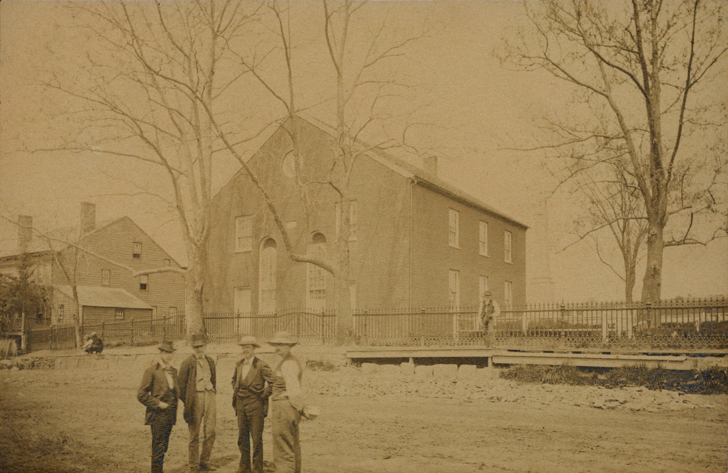
Figure 7. Photograph showing the Hopewell Baptist Church, the John Hart Monument (faded image to right of church building), and the new iron fence sometime between 1873 and 1875. The present Hopewell House to the left of the church is shown prior to its expansion and decorative alteration in the Second Empire-style through the construction of the present mansard-roofed third floor in 1876 (“Hopewell Baptist Church” c. 1874).
1875
The church, along with its associated cemetery and the new stables to the rear, was depicted on the map of the village of Hopewell included in the atlas of Mercer County published in 1875 (Figure 8a). The same features, along with the new iron fence, were shown in detail on a view of the property produced for the same atlas (Figure 8b). The sheds that had formerly stood at the front of the cemetery were no longer present.

Figure 8a. The Hopewell Baptist Church (“1st Bapt. Ch.”), the Hopewell Baptist Church Cemetery (“Gr. Yd.”), the horse and carriage sheds at the rear of the cemetery (“Stabling”), and the former Merrell House (then owned by Zephaniah Stout) in 1875. Source: Everts & Stewart 1875.

Figure 8b. The Hopewell Baptist Church, the Hopewell Baptist Church Cemetery, and the horse and carriage sheds in 1875; the former Merrell House was not represented. Source: Everts & Stewart 1875.
On June 9, 1875 it was reported that plans were underway to move the Hart monument (Hopewell Herald June 9, 1875). On June 15 it was recorded that the Trustees of the church had “paid cash for moving [the] Hart monument” and “for digging [the] foundation for monument” (A Book of Records 1770), and on the following day it was reported that the monument had been moved a short distance (the width of the base) to the northwest of its original location (Hopewell Herald June 16, 1875).
1887
The “Baptist Ch.-O.S. [Old School]” and cemetery, with the stabling to the rear, was depicted on the view of the village of Hopewell produced in 1887 (Figure 9).

Figure 9. The Hopewell Baptist Church (red arrow), the Hopewell Baptist Church Cemetery, and the horse and carriage sheds in 1887. Source: Fowler 1887.
1896
The Joab Houghton Memorial, honoring a patriotic oration made by Houghton in April of 1775 in the wake of the Battle of Lexington, was put in place immediately to the east of the Hart Monument and dedicated on July 4, 1896. Houghton, a prominent local resident who owned a farm one mile north of the present Hopewell Borough, gave his oration at the front of the church as he sought to recruit volunteers for military service. He stood on a large stone that had been put in place to serve as a carriage step, or mounting block, for the convenience of members of the congregation. Houghton would go on to serve as an officer in the New Jersey Militia and the New Jersey State Troops during the conflict, rising to the rank of Lieutenant Colonel, and after the war he served in the New Jersey State Legislature. The monument exhibits a base of diabase blocks supporting the sandstone carriage step/mounting block, with an inscribed sandstone marker at the front (Gray 1896; Ege 1908).
In January of 1897 it was recorded that funds had been raised for the “new iron fence and resetting old fence” (Account Book n.d.). This may refer to the fence still in place to the west of the church, the posts of which bear the marking “DAVID PETTIT & CO., PHILA.,” referring toan ornamental iron works active in Philadelphia during the latter part of the nineteenth century. The entry for the “resetting” of the old fence may refer to the alteration of the fence along the front of the church. This alteration involved the removal of the several fence segments and the two gates along the front of the building, leaving it open to the sidewalk, and the creation of the current recessed configuration, with two gates now flanking the church on both sides. It seems probable that the two fencing segments and the gates were reused from the original fence. The posts adjacent to the building for both gates are the same Pettit posts utilized for the fence to the west. A photograph of the church published in 1897 shows the fence in its present configuration (Gray 1897).
1900
On December 10, 1900 a “Special Meeting” was held “to discuss the matter of Heating the House,” with it voted “to go on with the work according to the Plans & Specifications of C H Blackwell” (A Book of Records 1770).
The church made payments for work on done on the “Heater,” the “Heater House,” and the “Heater chimney” between late December of 1900 and March of 1901 (Account Book n.d.).
1901
On January 2, 1901 it was reported that “The warming and ventilating system at the Old School Baptist meeting house was put in operation yesterday and is working very satisfactorily” (Hopewell Herald January 2, 1901).
1902
The brick “1st Bap’t. Church,” along with the new heating plant addition attached at the rear of the building, was depicted on the fire insurance mapping produced for Hopewell in 1902 (Figure 10).

Figure 10. The Hopewell Baptist Church and the western section of the Hopewell Baptist Church Cemetery in 1902. The western ends of the three sheds to the north of the church were also shown, as was the J.H. Titus Livery and the firehouse to the rear of the Hopewell House—the firehouse was actually on the property owned by the church. Source: Sanborn Map Company 1902.
1905
In 1905 the congregation agreed “to repair the fence between the Cemetry and Hotell property” (A Book of Records 1770).
Chronological History of the Expansion of
the Hopewell Baptist Church Cemetery
1779
John Hart acquired the larger property from which the original lot for the Hopewell Baptist Church had been subdivided sometime prior to his death in 1779. This larger property, which consisted of some 79.25 acres of land and originally included frontage on West Broad Street extending from North Greenwood Avenue to the vicinity of Louellen Street, was left by Hart to his eldest son Jesse Hart. It was noted that three properties on West Broad, including “the meeting house” on the original church lot (see Parcel 1 on Figure 1), were not included in this bequest (New Jersey Will 1079J).
1784
In 1784 Jesse Hart lost the property he had inherited from his father as a consequence of two lawsuits seeking compensation of unmet mortgage responsibilities (New-Jersey Gazette June 7, 8, 23, 1784; February 7, 1785).
1785–1787
Sometime between 1785 and 1787 a 15-acre portion of the former Jesse Hart property fronting on West Broad was purchased by William Dawlis. In 1787 Dawlis was sued in the Hunterdon County Court of Common Pleas, again as a consequence of mortgage issues associated with the 15-acre parcel (Deed—Sheriff to John Blackwell 1789).
1789
In 1789 the 15-acre property of William Dawlis (which actually included nearly 17 acres) was sold to John Blackwell in the sheriff’s sale that resulted from the 1787 suit. The property’s eastern terminus on West Broad was North Greenwood, with its western terminus being 779 feet to the west at the east line of the original church lot. The former Dawlis line then ran northwest along the church line a distance of 198 feet and then angled southwest to run along the rear line of the church lot and two other lots sited to the west of the church (Deed—Sheriff to John Blackwell 1789).
This deed fixes the location of the east and north lines of the original church lot and defines the depth of the lot as 198 feet. The lots for 14, 18, 22, and 24 West Broad and the lots that would later be absorbed into the church property (see below), all surveyed during the late eighteenth century and early nineteenth century, were also 198 feet in depth. The property purchased by John Blackwell in 1789 included all of the present church property with the exception of the original church lot (see Parcels 2, 3A, 3B, 4, and 5 on Figure 1).
In 1791 John Blackwell sold the former Dawlis property to his cousin John T. Blackwell (see Hunterdon County Deed 10 12).
1804
In 1804 John T. Blackwell sold the bulk of the former Dawlis property to George W. Case, retaining only a lot on West Broad with 198 feet of frontage extending east from the east line of the original church lot, a holding that would later become part of the church cemetery (see Parcels 2 and 3A on Figure 1). The tract conveyed to Case included 111 feet of frontage on West Broad that would later form the southeastern corner of the cemetery (see Parcel 3B on Figure 1) (Hunterdon County Deed 10 12).
1812
On April 1, 1812 John T. Blackwell sold the lot with 198 feet of frontage on West Broad to the east of the church to Benjamin Merrell for only $105, with this purchase price indicating that the lot was undeveloped (Hunterdon County Deed 19 245; see also Hunterdon County Mortgage 5 177). On May 1 Merrell bought the adjacent lot with 111 feet of frontage from George W. Case, with this lot also being undeveloped as the purchase price was only $50 (Hunterdon County Deed 20 444). These acquisitions gave Merrell a large lot on West Broad with a total of 309 feet of frontage extending east from the church property (see Parcels 2, 3A, and 3B on Figure 1).
Merrell constructed and resided within a house sited on this large lot, where he also built and operated a wheelwright shop (Hopewell Herald February 17, 1875; March 10, 1875; Woodward and Hageman 1883; Boggs 1894). He was recorded in the federal census as being in residence in Hopewell Township, likely on this property, in 1830 and 1840 (United States Census of New Jersey 1830; 1840).
1821
In 1821 John R. Hagaman and Benjamin Merrell submitted a receipt for work done “repairing [the] meeting House” (Registrum Baptismale 1749; see Figure 2). This may suggest that Merrell’s house to the east of the church had been completed sometime between 1812 and 1821 and that he was in residence in 1821. Hagaman, who was also a wheelwright (United States Census of New Jersey 1850; he then lived in Amwell Township), would be extremely active in matters associated with the church during the next quarter century. He was married to Sarah Boggs Hagaman, the daughter of John Boggs, who was then the Pastor of the Hopewell Baptist Church, a position he would hold for nearly four decades. Hagaman, his second wife Ellen Sutphen Hagaman, and his son John N. Hagaman would all later occupy the Merrell house (see below).
1847
Zephaniah Stout was elected to serve as President of the Board of Trustees of the Hopewell Baptist Church in 1847 (A Book of Records 1770; see Figure 3). Stout would take a leading role in the affairs of the church, frequently as a Trustee and sometimes as the President of that body, until the time of his death in 1881 (he also made a significant number of bequests to the church in his will). He worked frequently with John R. Hagaman on various projects associated with the church, and after his acquisition of the Merrell property he allowed Hagaman and his family to live there as his tenants.
Benjamin Merrell died without leaving a will in 1847. The inventory of his personal property reflected both the house (“Kitchen,” “up stairs,” “Chamber,” and a range of household goods) and the wheelwright shop (“Lot of Wheel Wright tools,” “Lot of Waggon lumber in shop,” “Waggon Weels in shop,” and “Barrels in shop”) that stood within what would later become the Hopewell Baptist Church Cemetery (Mercer County Inventory A 431). The administrator of the estate of Benjamin Merrell conveyed the deceased’s property to his widow Elizabeth Merrell later that same year (Mercer County Deed L 530).
1848
Elizabeth Merrell sold the property on West Broad to Phebe Cook in 1848 (Mercer County Deed N 405).
1849
A “W S” (wheelwright shop) was shown to the east of the Hopewell Baptist Church and Columbia School on the map of Mercer County published in 1849 (see Figure 4; the former Merrell House, although then still standing, was not depicted).
1851
On May 24, 1851 the church decided to approach Phebe Cook to ask if “her lot adjoining the grave yard is for sale.” In August Zephaniah Stout and a second member of the church were directed to consult with Cook “in regard to the purchase of her lot for the purpose of a burying ground.” In September it was reported that she had not decided whether or not to sell, but by November she had altered her stance and was willing ‘to sell a part or the whole of her lot” (Registrum Baptismale 1749).
1852
On January 21, 1852 Zephaniah Stout purchased the former Merrell property, which was said to include 1.39 acres, from Phebe Cook for $619 (Mercer County Deed W 313). Three days later Stout reported to the church “that he is at present the owner” of the Cook lot and that “the church can have the whole or any part of it” (Registrum Baptismale 1749).
On April 27th Stout conveyed a quarter-acre lot from the western end of the former Merrell property, which included 55 feet of frontage on West Broad extending east from the original church lot, to the “Trustees of the Baptist Congregation in Hopewell” (Mercer County Deed X 576) (see Parcel 2 on Figure 1). On May 22 the sale of burial lots within a section “of the land bought of Z. Stout as an addition to the burying ground” was authorized by the church (A Book of Records 1770).
In a June 12 Trustees meeting “It was also unanimously agreed that the deed presented by Zephaniah Stout for lot of land bought of him be accepted.” The Trustees also agreed “to execute Deeds for six shed lots sold off of lot bought of Z. Stout” (A Book of Records 1770). The deeds for three of these shed lots, all also dated June 12, survive within the collections of the Hopewell Museum. All three lots were 20 feet deep, with two eleven feet in width and one nine feet wide, and were described as being bounded on the south by “the highway,” or “the public highway,” references to the present West Broad Street, informing that they were sited along the West Broad frontage of the former Stout lot (Deeds—Trustees of the Baptist Congregation in Hopewell 1852).
In a June 12 meeting of the congregation it was noted that the church was looking into “fencing the grave yard,” with it resolved “to put up a substantial stone wall on the north side of the yard to be laid in lime & sand and covered with boards” and “to put up a paling fence on the East side of the yard” (Registrum Baptismale 1749).
On June 26 the church agreed “that Deacon Hagaman shall have the privalege of the grass on the new part of the graveyard” (Registrum Baptismale 1749). This reference may indicate that John R. Hagaman, then serving the congregation as Deacon, was living in the former Merrell house and had some use for the grass in the adjacent property recently sold to the church by Zephaniah Stout for the expansion of the cemetery.
1854
In October of 1854, with the former Columbia School to the east of the church having been recently demolished, the church ordered that “three shed lots east of the meeting house where the school house formerly stood” be laid out and sold off (A Book of Records 1770). These new sheds, when combined with the six sheds adjacent to the east that had been erected several years earlier on the former Stout lot, gave the church a total of nine sheds sited along the West Broad Street frontage of the cemetery.
1860
The former Merrell house on the property still owned by Zephaniah Stout was shown as being occupied by “J.R.Hegeman” on the map of the region published in 1860 map (see Figure 5). John R. Hagaman (apparently the family’s preferred spelling), who had actually died in the previous year, apparently occupied the house in the years preceding his death as Stout’s tenant.
Ellen M. (Sutphen) Hagaman, the second wife and widow of John R. Hagaman, was listed as the occupant of the house, along with her son John N. Hagaman and two additional children, in the federal census of 1860 (United States Census of New Jersey 1860; see also Hopewell Herald February 17, 1875; March 10, 1875). In 1881 it was reported that during the 1860s Zephaniah Stout had built an addition to the house on West Broad then occupied by Ellen M. Hagaman (Hopewell Herald November 9, 1881) (www.findagrave.com).
1869
The lithograph owned by the Hopewell Museum depicts the Hopewell Baptist Church and a portion of its associated property in 1869. The three-stall shed that had been built circa 1855 on the former site of the school was shown, but the view did not extend far enough to the east to show the six adjacent sheds built circa 1852 (see Figure 6).
1870
John N. Hagaman, the son of John R. and Ellen M. Hagaman, was recorded as the sole occupant of the former Merrell house in the federal census of 1870 (United States Census of New Jersey 1870).
1871
In October of 1871 the congregation considered a plan “to fence the lot of Brother Z. Stout where we meet for baptisms” (Book Number Two n.d.). The said lot was located in the southwest angle of the present Hopewell-Rocky Hill and Aunt Molly Roads with a tributary of Bedens Brook forming its western boundary.
1872
On May 18, 1872 Zephaniah Stout conveyed the 2.07-acre baptismal tract to the church (Mercer County Deed 90 276). On May 25 it was recorded that Stout had given the church “a deed for over two acres of land embracing the water wherethe Church has met for over one hundred years to administer the ordinance of baptism” (Book Number Two n.d.).
1873
On April 25, 1873 Zephaniah Stout purchased a single-acre strip of land that extended along the rear of the original church lot, the parcel sold to the church by Stout in 1852, and the entire former Merrell property (Mercer County Deed 96 428) (see Parcel 4 on Figure 1). This deed makes it clear that Stout had conveyed the remaining parcels of the former Merrell property (see Parcels 3A and 3B on Figure 1) to the church by 1873. It seems likely that he granted the northern strip of land to the church shortly after acquiring it. The deeds recording the conveyance of these properties were not publicly recorded and have not been identified.
In September of 1873 a motion was made “that the sense of the meeting be taken whether they are willing to have the stone wall in front of the Meeting House removed to be replaced by an iron fence.” The motion was made and it was determined that “the Church is willing it should be removed” (Book Number Two n.d.).
On November 4, 1873 the Trustees authorized Zephaniah Stout to sell “that portion of the land for burial lots recently occupied by sheds for the sheltering of horses and carriages,” noting that he has “furnished shed lots north of the graveyard” (A Book of Records 1770). This likely refers to all of the sheds at the front of the cemetery, which were to be replaced by new sheds within the northern strip of land at the rear of the cemetery. The removal of the sheds also cleared the way for the installation of the proposed iron fence to be sited along the front of the cemetery.
1873–1875
The Hopewell Baptist Church and a portion of its associated property was photographed sometime between 1873 and 1875 (see Figure 7). The iron fence along the property’s West Broad Street frontage, which was not in place in 1873 and is known to have been in place by 1875, was prominently featured in the foreground of the photograph.
1875
The former Merrell house was shown and identified as being owned by “Z. Stout” on the map of Hopewell in the county atlas of 1875 (see Figure 8a). The view of the church and cemetery included in the atlas did not, however, depict the house, and, in fact, represented the cemetery as occupying its full and present frontage on West Broad (see Figure 8b). The new sheds to the rear of the cemetery were shown to be located on the strip of land that Stout had acquired in 1873 and passed on to the church, with the sheds that had formerly stood at the front of the cemetery no longer in place.
The iron fence bears the markings “FIRST BAPTIST CHURCH OF HOPEWELL – JOSEPH B YARD, MAKER, TRENTON N J” on two of its gates. Joseph B. Yard was active as an “Iron Railing Manufacturer” in Trenton beginning in 1850 and continuing into the 1880s (United States Census of New Jersey 1880; Industries of New Jersey 1882).
1887
The view of Hopewell published in 1887 depicted the church property at its full extent along West Broad and as encompassing the strip of land to the rear occupied by the stables (see Figure 9).
1900
On June 4, 1900 Mary Q. Purington, the widow of former pastor William J. Purington, purchased a narrow tract of land adjacent to the north line of the cemetery and the church “shed lots” (see Parcel 5 on Figure 1) (Mercer County Deed 241 371).
1902
The stabling at the rear of the cemetery and to the north of the church was partially represented on the fire insurance map for Hopewell published in 1902, and was shown to then consist of three rows of sheds (see Figure 10). Also depicted was a small firehouse attached to the eastern end of the “J.H. Titus Livery,” which stood to the rear of the present Hopewell House, then in use as a hotel—of note was the fact that the firehouse was actually sited within the church property.
It seems likely that this firehouse was associated with the Union Fire Company, which was formed in 1895 (Hopewell Herald April 4, 25, 1895). John H. Titus, the owner of the livery stable, was named to serve as Union’s Foreman in that year (Hopewell Herald September 17, 1895), and he would later serve as the Company’s Chief (Hopewell Herald March 11, 1908). The “engine room” of the Union Fire Company was noted in 1901 (Hopewell Herald May 15, 1901).
1907
In 1907 Mary Q. Purington conveyed the parcel she had acquired in 1900 to the church (see Parcel 5 on Figure 1)(Mercer County Deed 298 123). This acquisition brought the church property to what is essentially its present extent.
1912
The church and the cemetery were represented on the fire insurance map published in 1912. Of note are the three rows of “Team Sheds” to the rear of the church and the presence of the firehouse within the church property (Figure 11).

Figure 11. The Hopewell Baptist Church and Cemetery in 1912, with the three rows of “Team Sheds” shown to the rear of the church. The “Fire Dept. Eng. Ho.” was depicted extending into the eastern section of the cemetery. Source: Sanborn Map Company 1912.
1917
The tax map of Hopewell Borough produced in 1917 did not show an extension for the firehouse into the church property (Lanning 1917), suggesting perhaps that the church had allowed the construction of the building through some sort of more informal agreement and that the present rectangular extension into the church property was the result of amorerecent transaction.
1927
The 1927 insurance map showed only the southernmost of the sheds to be remaining, with the former firehouse shown to be in use as part of the garage that had replaced the stable to the rear of the Hopewell House (Sanborn Map Company 1927). This last shed was removed at mid-century, with the former firehouse demolished and replaced by the present structure during the 1970s (www.historicaerials.com).
References
A Book of Records For the Trustees of the Baptist Church in Hopewel New Jersey, 1770. Entries through 1926. Manuscript. From Hopewell Museum, Hopewell, New Jersey.
Account Book [first] of the Trustees of the First Baptist Church of Hopewell, New Jersey, n.d. Entries from 1888 through 1902. Manuscript. From Hopewell Museum, Hopewell, New Jersey.
Ashton, Dean H, 1960. Hopewell Academy (Forerunner of Brown University) and the Lives of Outstanding Graduates. Unpublished Manuscript. Hopewell: Dean H. Ashton.
Boggs, John. “Hopewell Reminiscences.” Hopewell Herald. January 25, February 1, 8, 15, 1894. From www.ancestry.com and www.newspapers.com.
Book Number Two—Minutes of the Hopewell Old School Baptist Church Business Meetings, n.d. Entries from 1844 through 1918. Manuscript. From Hopewell Old School Baptist Church, Hopewell, New Jersey.
Collins, John, 1869. “Hopewell Baptist Church.” Lithograph. From Hopewell Museum, Hopewell, New Jersey.
Davis, Jack, 2016. “Old vs. New School: A Baptist Controversy in Hopewell.” Hopewell Valley Historical Society Newsletter XXXIV (4).
Dean, William. “Your Neighbors Fifty Years ago—Who Were They?” Hopewell Herald. February 17, February 24, March 3, March 10, March 17, and March 24, 1875. From www.ancestry.com and www.newspapers.com.
The Dedicatory Exercises and Public Inspection of the Hopewell Grammar School, 1926. Pamphlet. Hopewell: Hopewell Grammar School.
Deed – Sheriff to John Blackwell, 1789. Manuscript. From Hopewell Museum, Hopewell.
Deeds – Trustees of the Baptist Congregation in Hopewell, 1852. Manuscripts. From Hopewell Museum, Hopewell, New Jersey.
Ege, Ralph, 1908. Pioneers of Old Hopewell, New Jersey. Hopewell: Race & Savidge.
Everts & Stewart, 1875. Combination Atlas Map of Mercer County. Philadelphia: Everts & Stewart.
Fowler, T.M., 1887. Hopewell, New Jersey. Morrisville: T.M. Fowler.
Gray, Nomar, 1896. Hopewell’s Celebration of the 120th Anniversary of the Declaration of Independence: The Unveiling of the Houghton Memorial. Hopewell: C.E. Voorhees.
Gray, Nomar, 1897. Healthful Historic Hopewell. Hopewell: C.E. Voorhees.
“Hopewell as it was About the Year 1800.” Hopewell Herald. September 7, 14, and October 5, 1881. From www.ancestry.com and www.newspapers.com.
“Hopewell Baptist Church.” c. 1874. Photograph. From Hopewell Museum, Hopewell, New Jersey.
Hopewell Herald. Various dates. From www.ancestry.com and www.newspapers.com.
Hunter, Richard W., and Richard L. Porter, 1992. Hopewell: A Historical Geography. Hopewell: Hopewell Township Historic Sites Committee.
Hunterdon County Deeds. New Jersey State Archives, Trenton.
Hunterdon County Mortgages. New Jersey State Archives, Trenton.
Industries of New Jersey, 1882. Newark: Historical Publishing Company.
“The John Hart Monument,” 1866. Documents of the Ninetieth Legislature of the State of New Jersey. New Brunswick: J.F. Babcock.
Lake, D.J., and S.N. Beers, 1860. Map of the Vicinity of Philadelphia and Trenton. Philadelphia: C.K. Stone & A. Pomeroy.
Lanning, Henry L., 1917. Borough of Hopewell Tax Maps. Manuscript. From New Jersey State Archives, Trenton.
Lumber Receipts, 1822-3. Manuscripts. From Hopewell Museum, Hopewell, New Jersey.
Mercer County Deeds. New Jersey State Archives, Trenton.
Mercer County Inventories. New Jersey State Archives, Trenton.
“Miss Weart School Speaker.” Hopewell Herald. June 25, 1947. From www.ancestry.com and www.newspapers.com.
New Jersey Gazette. Various dates. From www.genealogybank.com.
New Jersey Wills. New Jersey State Archives, Trenton.
Otley, J.W., and J. Keily, 1849. Map of Mercer County. Camden: Lloyd Van Der Veer.
Porter, Richard L., 2023. Chronological History of the Hart/Phillips Farmstead. Manuscript. Hopewell Museum, Hopewell, New Jersey.
Purington, William J., 1882. Historical Sketch of the Old School Baptist Church. Pamphlet. Hopewell: Hopewell Old School Baptist Church.
Registrum Baptismale or a Church Book, 1749. Entries through 1855. Manuscript. From Hopewell Museum, Hopewell, New Jersey.
Sanborn Map Company, 1902, 1912, and 1927. “Hopewell, Mercer County, New Jersey.” New York: Sanborn Map Company.
United States Census of New Jersey. New Jersey State Archives, Trenton.
Woodward, E.M., and John F. Hageman, 1883. History of Burlington and Mercer Counties. Philadelphia: Everts & Peck
Copyright © 2024 by Richard L. Porter and The Hopewell Museum. All rights reserved.